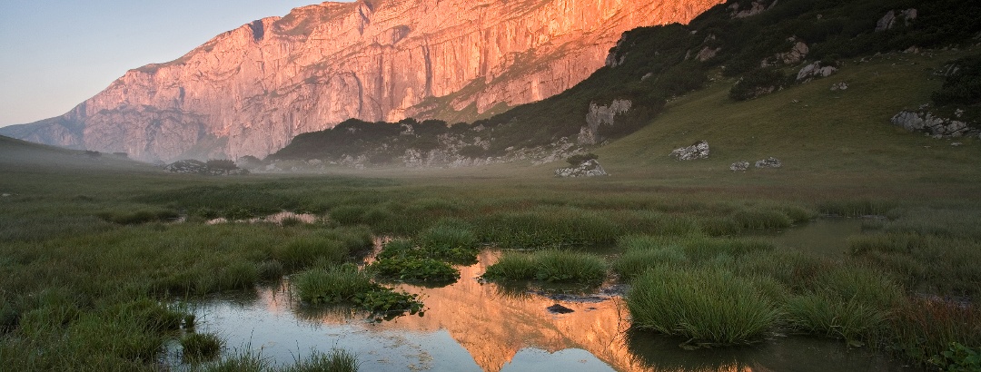
Skip to content
  • Map
  • Route Finder
  • Route Planner
  • Travel Guide
  • Community
Sign up or log in
  • Map
  • Route Finder
  • Route Planner
  • Travel Guide
  • Community
Sign up
  • Places & Accommodation
    • Places to visit
    • Eat & drink
    • Huts
    • Accommodation
    • Ski resorts
    • Crags
  • News & Conditions
    • Current Conditions
    • Weather
    • Webcams
    • Avalanche Report
    • Events
  • Inspiration
    • Collections
    • Offers
    • Travel Stories
    • Publications
  • Community
    • Challenges
    • Groups
  • Settings
  • Help
Travel Guide Rofan Mountains
more
  • Mornings in the Rofan Mountains
    Mornings in the Rofan Mountains Photo: Achensee Tourismus
  • Hiking in the Rofan Mountains
    Hiking in the Rofan Mountains Photo: Achensee Tourismus

Rofan Mountains

The Rofan Mountains are located in the western part of the Brandenberg Alps, between Lake Achensee and Inn Valley. It consists of the main ridge with well-known peaks such as the Klobenjoch, the Hochiss, the Seekarlspitze and the Rofanspitze. The Dalfazer Wände with the Dalfazer Joch and Rotspitze are connected to it. A little farther south is another ridge including the Sagzahn, Sonnwendjoch and Haidachstellwand.
Find out more
Outdooractive Editors  Verified partner 
Author of this page
LogoOutdooractive Editors

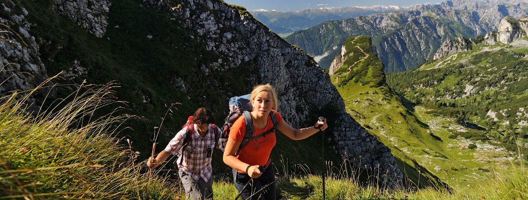
Activities in the Rofan Mountains


hikes
mountain biking trails
mountain hikes
bike rides
road cycling routes
bicycle tours
long-distance hikes motor bike routes ski tours winter hikes snowshoe walks trail runs pilgrim walks nature trails via ferratas runs caravan trips cross-country ski trails alpine climbing routes horse rides sledding runs scenic routes gravel bike routes Ski resorts

Attractions in the Rofan Mountains


Highlights

  • My Map
  • Content
  • Show images Hide images
Features
2D 3D
Maps and trails
Discover
Mountain Hike · Rofan Mountains
Guffert (2194 m) from Steinberg
Toprecommended route Difficulty moderate
Distance 10 km
Duration 6:00 h
Ascent 1,180 m
Descent 1,180 m

From Steinberg am Rofan via the normal route (south ascent) to the striking rock pyramid

from Michael Pröttel,   alpenvereinaktiv.com
Hiking route · Alpbachtal
Kirchrain stroll with viewing platform (barrier free)
Toprecommended route Difficulty easy
Distance 0.3 km
Duration 0:15 h
Ascent 5 m
Descent 5 m

Pleasant barrier-free route located on the sunny plateau in Brandenberg

from Alpbachtal Tourismus,   Alpbachtal Tourismus
Mountain Hike · Rofan Mountains
Bergtour über Rofanspitze, Sagzahn und Vorderes Sonnwendjoch im Rofan
Toprecommended route Difficulty moderate
Distance 10.9 km
Duration 4:30 h
Ascent 750 m
Descent 750 m

Im Herz des Rofan Landschaftlich extrem abwechslungsreiche Rundtour über drei Gipfel im zentralen Rofan mit herrlichem Weitblick ins Karwendel, ...

from Andreas Erkens,   ALPIN - Das Bergmagazin.
Mountain Hike · Rofan Mountains
Bergtour auf den Hochiss im Rofangebirge
Toprecommended route Difficulty moderate
Distance 7.8 km
Duration 3:45 h
Ascent 630 m
Descent 630 m

Steiler ZahnViel begangener Anstieg auf den höchsten Gipfel des Rofan. Der Abstieg führt vorbei an der Dalfazalm, einer überaus empfehlenswerten ...

from Stefan Herbke,   ALPIN - Das Bergmagazin.
Mountain Hike · Achensee
4-2000 metre round tour in the Rofan
Toprecommended route Difficulty moderate
Distance 10.1 km
Duration 6:00 h
Ascent 850 m
Descent 850 m

A very rewarding and scenic circular tour starting at the Erfurter Hütte to the Rofanspitze 2259m, on to the Seekarlspitz 2261m, then over the ...

from Leopold Brandner,   alpenvereinaktiv.com
Hiking route · Steinberg am Rofan
Swisstrack hike Steinberg am Rofan (barrier-free)
Toprecommended route Difficulty moderate
Distance 19.5 km
Duration 3:45 h
Ascent 704 m
Descent 694 m

Wonderful hike with panoramic views of the Rofan mountains, along the narrow valley of the Steinberger Ache, past mighty rocks and waterfalls.

from Gerda Pamler,   alpenvereinaktiv.com
Hiking route · Achensee
Kotalm - Köglalm - circular hike
Toprecommended route Difficulty moderate
Distance 9.5 km
Duration 3:30 h
Ascent 730 m
Descent 730 m

A fine hiking tour above Lake Achensee with two mountain huts for resting.

2
from Elisabeth Reder,   alpenvereinaktiv.com
Discover more
  • My Map
  • Content
  • Show images Hide images
Features
2D 3D
Maps and trails
Discover

Discover the region

Eat and drink
huts
Dog-friendly hiking
Accommodation
Accessibility
Webcams

Trip planning


Weather

Webcams

  • Webcam · Achensee
    Pertisau: Achensee
  • Webcam · Kufsteinerland
    Vorderthiersee: Hinterthiersee
  • Webcam · Kufsteinerland
    Vorderthiersee: Kufstein - Kaisergebirge
  • Webcam · Achensee
    Gemeinde Achenkirch › South
  • Webcam · Achensee
    Gemeinde Achenkirch › North
Show all Webcams in the Rofan Mountains

Reviews

  488
Achensee Teil 2 - Von der Gaisalm zur Anlegestelle Scholastika by X
June 11, 2024 · Community
More Show less
Comment
ATG1-08 Tour Bayreuther Hütte/ Erfurter Hütte (8th day) by Bernard
June 07, 2024 · Community
Comment
Vorderunnütz, round tour from Steinberg by Claudia
May 27, 2024 · Community
More Show less
Comment
Show more Show less

Groups

Camramblers Walking Club
6 members

Destinations in the Rofan Mountains


THE way to start your next outdoor experience!
Sign up now
App Store
Google Play Store
Huawei App Gallery
  • Our services
    • Features
    • Pro and Pro+
    • Pro for Search & Rescue
    • Enjoy benefits and discounts from our partners
    • Vouchers
    • B2B
  • More services
    • Help Center
    • Blog (German only)
    • Shop
    • Newsletter
    • Affiliate Program
    • Contact Us
  • Corporate
    • Discover Outdooractive
    • Outdooractive30
    • Careers
    • Outdooractive Business
Learn more about the apps for Android and iOS
1% for the Planet Digitize the Planet
Choose a language
English
  • Deutsch
  • italiano
  • français
  • español
  • עברית
  • 中文
  • română
  • português (Portugal)
  • português (Brasil)
  • čeština
  • suomi
  • русский
  • magyar
  • norsk bokmål
  • slovenčina
  • Nederlands
  • 日本語
  • українська
  • हिन्दी
  • Türkçe
  • Ελληνικά
  • Mobile version
  • Terms and conditions
  • Privacy policy
  • Cancellation policy
  • Customer information
  • Terms of payment
  • Map information
  • Legal Disclosure